
To keep in shape for next weekends attempt at the Timberline Trail, I really needed to get out and do some climbing this weekend. Last weekend along the Salmon River I did an overnighter with my partner and one of our friends. This area is in the Salmon-Huckleberry Wilderness. By my strava it looks like I was able to get around 5600′ of climbing in yesterday and today. This is nothing compared to the 12000’+ of cumulative elevation gain we’ll be attempting next weekend.
Here’s the loop I did this weekend, red part is Day 1 (yesterday) and green part is Day 2 (today). These trail images are from Caltopo. (If you havent used Caltopo before, I highly recommend it for trip planning and backup navigation in the field. Look at my tutorial here).
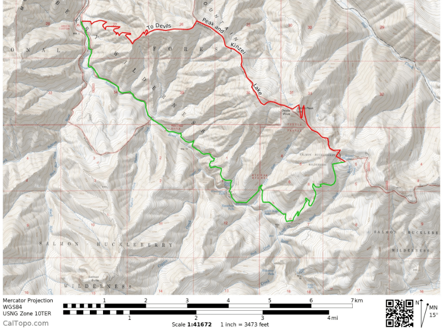
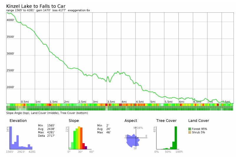
It looks easy, especially when you look at the scale on the map above. That climb was a bitch though. It started around 1600′ and Devils Peak is at a little over 5000′. That was the whole point though. I needed to keep in shape and its not supposed to be a pleasure hike for the whole time. The readout below from Caltopo is close, but doesn’t exactly match my Strava results. NBD.

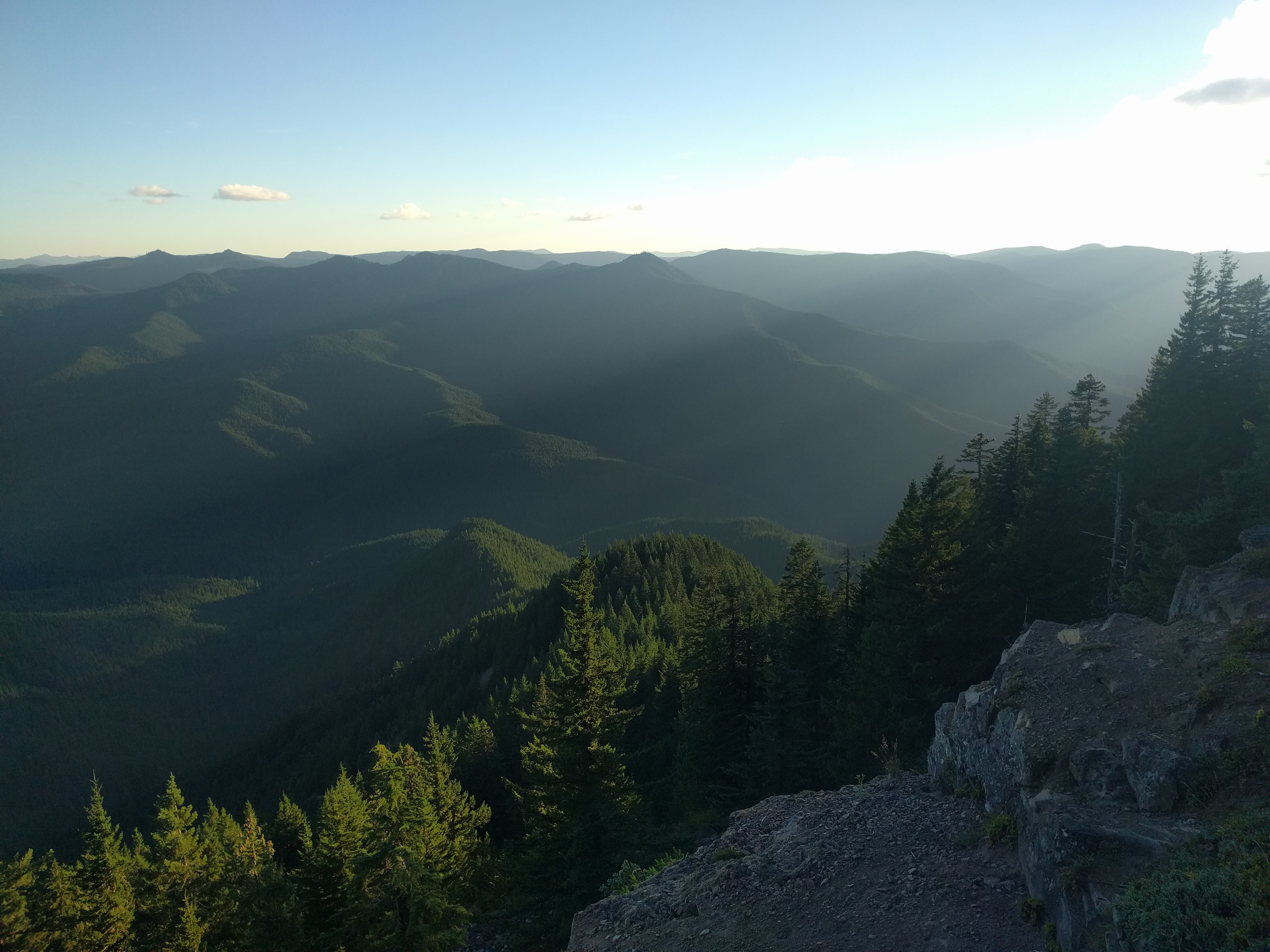
It was mainly a forested hike with only a few good views. The rewards at the top were worth it. On Devils Peak there is even an old Forest Service fire lookout. I descended a bit from here down to Kinzel Lake, which is really more of a shallow tarn. It wasn’t freezing or windy out, so I slept under the stars and didn’t use my tarp. In the photo you can see my homemade quilt and my new sleeping pad that I’ve been using all summer. For those interested in the gear I’m using, the pack is a Granite Gear Leopard 58 that I use without the lid.


This morning I woke up and felt like shit, and pissed a golden yellow. Clearly I was dehydrated. I “caught up” and eventually felt hydrated as I cruised downhill from Kinzel Lake into the Salmon River Canyon.
As the day wore on, it got hotter and more humid and I just wasn’t taking enough water in. I took a user trail in hopes of seeing Vanishing Falls, and wound up finding a prime spot I’ll be coming back too. I ate lunch here and popped an ibuprofen, thinking I was sick. I felt almost feverish. I drank a liter of water here. As I went off-trail traversing along the canyon wall I felt horrible and became disoriented and had shaky legs for a few minutes. I felt really hot and regretted going off trail alone at this point. I pushed through, connecting with another faint user trail further down the canyon that brought me back up to the real trail. My mouth felt dry, and for the remainder of the hike I pounded water as best I could with my Sawyer Mini.
To be honest I think the Sawyer Mini is a bit problematic in this regard. You have to work for your water, simultaneously sucking the hell out of it while squeezing the shit out of your Smart water bottle. Today I thought I was getting more water than I really was. The result was that the math didn’t add up and I got dehydrated to the point of feeling sick. Next weekend, I’ll be taking my regular Sawyer that has a better flow rate so I can piss clear the whole time. I did manage some sweet shots though of the area near Frustration Falls:


For a total of around 16.5 miles and over 5500′ of climbing, this is a great loop with a ton of places to camp. Its keeping me in shape enough to where hopefully next weekend isnt a death march. Most spots I saw were empty and I only saw a few other backpackers. You can do a longer loop like I did today, or hike in as little as a half mile and camp out. I think this is my 7th trip here in 2016. I keep finding new spots tucked away and new places to check out and explore. For being an hour away from the city, I think this area is a real gem with a great combo of beauty, accessibility and a wide variety of hiking options that can make it great for newbs and more experienced backpackers alike.

Great report. My wife and I did that hike back in June when we had that hot streak. We were pretty desperate for water on the ascent. Filled up at the meager spring before the lookout.
We just finished the Timberline Trail, yesterday. Ran into the crew working on the trail closure at Elliot. They said they were opening it up, but we had already passed it. The ranger station will probably have more info.
LikeLike
Thanks CC. I tried to find that spring right before the summit… but couldnt and neither could a guy that was camping right there. Glad you were able to find it. Im excited for the Timberline, did you do it over 3 days? Did they say when they were going to open the new part?
LikeLike
Yeah, the spring was hard to spot. We found a wet area and traced it back. We did it in 3 days, went clockwise and camped before muddy fork and then at cloud cap. The workers said they were opening the path on Tuesday. We talked to a volunteer at the start of our hike, and he advised us to skip the ropes (the one on the cloud cap side is gone now), and just walk through where the crew was working. If you are walking clockwise, instead of turning right to get to the bypass, go left. It seemed like the path follows the old timberline trail. If you are coming from cloud cap, go right at the sign with the maps. We called the zig zag ranger station before and they seemed pretty up to date on the progress, you might call them and ask for more detailed info.
LikeLike
THat is super helpful! I really appreciate the info!
LikeLike
If there is lone thing, you should be doing looking for yourself advantageous age – pinpoint as much stop for yourself as you can. Essay on home is the happiest place in the world. This means contacting a licensed web site theme serving to improve you with your papers. Bronze statue of eros sleeping essay. This is connected with doing yourself a favor and letting us do the responsibility for you while you sit following and relax.
LikeLike