
Last weekend, after our terrible night in Badger Creek Wilderness, we were greeted with perfect fall weather. The very last portion of our trail was a 1/2 mile off trail, in order to cut out walking on two miles of roads. After having taken a Compass Navigation Class at REI and watching videos on Compass Navigation, this was the perfect low-risk opportunity to practice these skills. We were also innocently unaware of the impending disaster that would happen on Election Day.
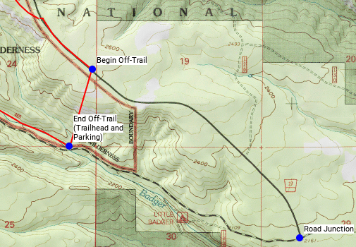
Below you can see the trail (in red) meet the road and follow it a bit going SE. In order to cut off a couple of miles of road walking to the junction and then west to the trailhead, I drew the straight line going SSW to represent the bushwhack to meet the trailhead where we started. Big time saver, and road walking sucks.
So to make things easier, when I got to the beginning of the off-trail segment I went on a South bearing instead of a SSW bearing. This way I’m sure to hit the dirt road, and when I do I just turn right and I’ll go right to my car. Basically, we headed south parallel to the N-S meridian line, nearly right on it.
We shot southern bearings to trees or rocks as we went along. I had GPS on my phone, but I opted to use the compass entirely and take off the training wheels for a moment. This wasn’t difficult, but that was kinda the point. No matter what, if I just walked downhill I’d be good to go.
I got an unexpected bonus for accuracy when I came upon these signs and markers left by the BLM. As I went south parallel to the N-S meridian (nearly on top of it) it led us straight to these markers which demarcate the intersection of the N-S line to the E-W line. Look at the marker on the ground and you can see the numbers correspond to the numbers of the quadrants on my map above.


This was a great training exercise in a good environment on a perfect day. I look forward to improving my skills and gaining comfort using my compass as a navigation tool in the back country.

Do not forget to incorporate the other nav tools you have with you. For example, if the off trail distance was a half mile, you could figure 15 minutes if moving at a decent pace, 30 min if it is pretty slow. Also, watch your altimeter — as you approach the elevation of the road, you know you should hit it shortly.
LikeLike
Excellent advice, thank you. Do you use a real altimeter? I only have my phone app altimeter at this point
LikeLike